Hussain Muhamed; Mustafa N. Hamoodi; Abd Alrazzak T. Ziboon
Abstract
Lake Hemrin is located in the middle east of Iraq, about 50 km from the Iraqi-Iranian border. The lake is the main fish source and provides water for nearby farms. However, due to various ...
Read More ...
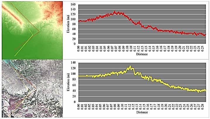
Lake Hemrin is located in the middle east of Iraq, about 50 km from the Iraqi-Iranian border. The lake is the main fish source and provides water for nearby farms. However, due to various socio-economic and environmental management issues, the Hemrin system is a difficult water resources challenge. Moreover, Lake Hemrin receives floodwaters annually over its storage capacity; therefore, there is a risk of flooding in the areas downstream of the lake. To this end, this research developed optimization solutions to design flood escape paths in the area using Analytic Hierarchy Process (AHP) and Genetic Algorithm (GA). Among three initial proposals, i.e., Adhaim River, Wadi Naft, and Salahdin, the developed models optimized each of the proposals and suggested that Wadi Naft would require only 3.88 km3 of cut and fill volume compared to Adhaim River of 34.33 km3. However, the latter would serve more people and agricultural lands. GA and AHP techniques to optimize flood escape paths have shown that these models can discover shorter pathways requiring less cut and fill costs while retaining other flood escape features. The proposed optimal flood escape path can substantially influence the construction of flood-prevention strategies in the area.